15% off for 2 & 20% off for 3 or more
discounts applied to your basket
Dorset County Maps
Year of Design - 2022
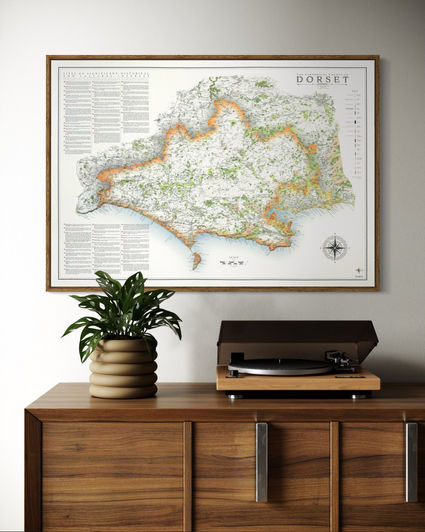
What a fascinating county Dorset is. There are two versions of the Dorset county map available. One has the two unitary authorities displayed in different colours, the other is a single colour to represent the whole ceremonial county without distinction of the unitary authorities.
I have also produced a map of the Dorset National Landscape.
Available in three sizes
Large: B1 - 100 x 70 cm (original design size)
Small: A1 - 84.1 x 59.4 cm
Reduced: B2 - 70 x 50 cm
(artwork a little more congested and about 5% of text labels removed)
Framed and unframed prints available available on 270 gsm archival fine art paper and 280 gsm cotton / polyester canvas. Visit the specifications page for more details.
Some of Dorset neighbouring counties have also been designed. Wiltshire, Devon and Somerset.
Details on the Map
The maps are packed full of details with woodland, moorland, rivers, streams, lakes, and a complete road and rail network. Civil parish boundaries and labels are across the maps along with long distance walking routes, world heritage sites and Jurassic coast, major tracks and paths, military areas and hilltops.
The coastline is densely labeled with all major features, bays and beaches.
Sites of Significant Historical and Cultural Interest are also labeled on the map with a researched reference section. Examples include Dorset Cursus, Sandsfoot Castle, Golden Cap and Old Harry Rocks, Purbeck Stone, The Monmouth Rebellion, Portland Bill and Christchurch Castle.


Dorset National Landscape Maps
Year of Design - 2022
The Dorset national Landscape map was created fro the original artwork of the Dorset county map. The NL stretches across much of the county with the border highlighted in my familiar burnt orange colour and vignetted grey.
The level of detail on the map is the same as the county map.
A supplementary map is added of the whole county showing the fully extent of the NL within it.
Available in three sizes
Large: B1 - 100 x 70 cm (original design size)
Small: A1 - 84.1 x 59.4 cm
Reduced: B2 - 70 x 50 cm
(artwork a little more congested and about 5% of text labels removed)
Framed and unframed prints available available on 270 gsm archival fine art paper and 280 gsm cotton / polyester canvas. Visit the specifications page for more details.
Mini Maps
My Dorset maps have also been re-designed for the mini map series. These have less labelling, prioritising place names, civil parish borders and labels are removed along with the walking routes.
The 'sites of significant historical and cultural interest' are also lost.
Three sizes available
Large: A2 - 59.4 x 42 cm
Medium: B3 - 50 x 35.3 cm
Small: A3 - 42 x 29.7 cm
Visit the Mini Map Series page for more details on the mini map series


